1 result
tagged
schenectady
Historical map of Schenectady County in the State of New York - David Rumsey Historical Map Collection

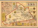
Conde, Edwin G.; Historical map of Schenectady County in the State of New York. Compiled and drawn by Edwin G. Conde 1931, Lithographed in Schenectady by Litto Craft. Copyright, 1931, by Edwin G. Conde. (insets) Map of old Schenectady. (with) Under three flags.; 8468.000; Detailed historical pictorial map, with title cartouche. Shows major bodies of water and rivers, railroads, places and buildings with emphasis on historical events, which are labeled throughout, lines indicating the roads, and historical routes. Includes notes on "Historical markers", County and city seals, Compass rose, and portraits of Lieut. Col. Christopher Yates, Joseph C. Yates, George W. Featherstonhaugh, and De. Eliphalet Nott.
September 13, 2023 at 11:02:09 AM EDT
*
FILLER